Last weekend I combined geocaching with my new rock tumbling hobby. I drove 55 miles N, mostly on the 14, to Gem Hill in Rosamond. It’s a famous location for rock hounds because it’s public land and collecting rocks is completely legal. Familiarity with Google Earth from geocaching was a huge help. Not only did it lead me to a wide open parking spot, it showed me an easy mostly flat ½ mile hiking trail around the back side of the hill.
The hike led here, where I’d seen the green ground cover on the satellite map. There was much evidence of previous digging. Inexplicably there were no geocaches.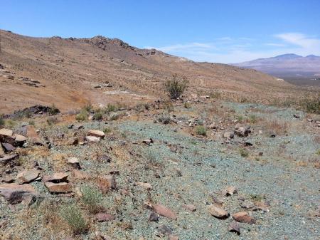
Youtube videos and online posts showed/described other rock collectors using shovels, sledgehammers and even a gas powered jackhammer to break rocks from exposed veins. I just picked up scraps that they missed. Visual scanning, another skill honed while geocaching was extremely helpful.
In 2 hours I collected enough rocks to make several batches of tumbled (polished) rocks and walked back to my Subaru. On my way to a MASSIVE cluster of caches, the Old Dusty Road series, I stopped for a closer look at an especially healthy Joshua tree.
They’re in bloom now. Or do pods count as blooms? I’ve heard that they’re edible but look closely. Those white wormy looking parts aren’t very appetizing. Near the SE intersection of the 14 & Backus Road I started caching at a random dirt road. Traveling was easy. And with both the 14 visible to the W and Sierra Hwy to the E there was no danger of being stranded without help.
The first cache, ODR’s #812 (GC7484B). It was an easy find only a few steps from the road as were half of the other 20 caches I visited. What’s “XMD?” It’s the Facebook mega-group “Explorers of the Mojave Desert.” And the magnetic “Geocaching” sign is for suspicious locals and law enforcement in case they drive up behind me. They might still demand to know what I’m doing but at least their first thought won’t be, “trash dumper,” “tortoise poacher,” or something similar.
Unlike most other desert series I’ve visited, the caches I found here were all camo’d and almost all in tough scratchy bushes. To be fair to the hider there weren’t many rocks or pieces of loose vegetation available to make geopiles. I DNF’d many because I didn’t want to rip up my hands reaching for containers I couldn’t see.
On the way back to Backus Road (fwy onramp is at the left edge of the bridge) my final find was a large non-series cache, Red Castle (GC71ETG).
There was a geocoin inside, the 3rd one I found on this trip. All 3 were old and owned by Jim, “f0t0m0m.” Maybe he dumped his collection into caches. He surely knows that the coins will inevitably disappear soon, taken by casual players who don’t know what to do with them. I DO know what to do and will drop them into non-urban caches in the hope that they’ll remain in circulation longer.
Dweeb's Diatribe
geocaching & hobby rants of OLdweeb
OLdweeb’s stat bar


Another great write-up, Ken! For some reason, we’ve never ‘hounded Gem Hill 😮 I need to make some time for that, maybe in the Fall. I’ve done a number of the ODRs, alone and with Webfoot, and they are mostly as you describe them. I also picked up two or three of Jim’s geocoins, which were still listed as being in his collection. I got no response to a “Are you sure about this?” inquiry, so I added them to our box of travelers to be dropped off, and will likely take at least one of them to Colorado with us next month. Pretty sure I already dropped one of them up in the Los Olivos area last month.